

By the co-directors
Jean-jacques Delannoy
Professor of geomorphology at university Savoie Mont Blanc, France.
&
Jean-Michel Geneste
Former Director, National Center for Prehistory, Ministry of Culture, France.
As soon as the Chauvet-Pont d'Arc cave was discovered in 1994, the French government, with its experience of Lascaux and the management of a large number of decorated caves, quickly invested in the protection and conservation of the site. The Chauvet-Pont d'Arc Cave is now listed as a UNESCO universal property and widely accessible to the public with the Chauvet 2 facsimile opened in 2015. The Ministry of Culture, supporting the publication of a monograph, the first volume of which is an atlas, initiated a multidisciplinary research program in 1997. The research has greatly benefited from the impulse and widely publicized work of the prehistorian Jean Clottes, to whom this work is dedicated.
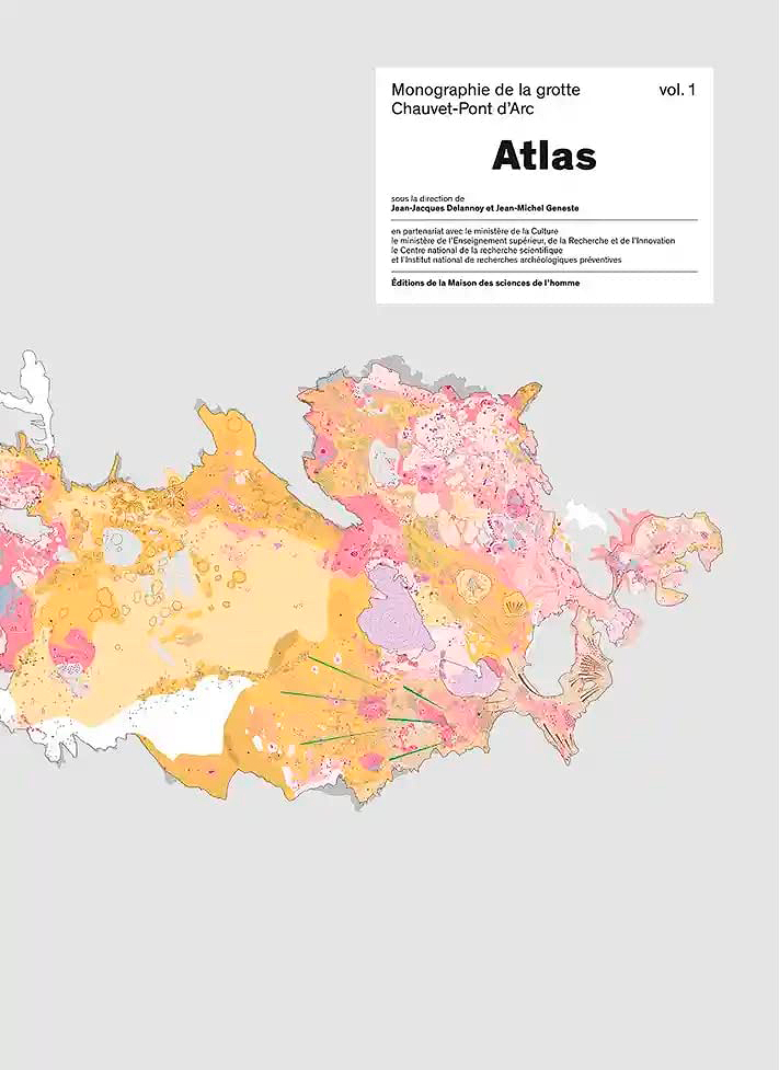
The Atlas is the first of four volumes of the Monographie de la grotte Chauvet-Pont d'Arc and aims to present the spirit of the research carried out in the Chauvet cave. The next two volumes will deal with the study of the cave's cave wall art; the fourth volume will be devoted to work on the numerous paleontological remains (cave bears in particular) and the relationship human-animal.
The authors chose to represent the cave through twenty 1/100 maps with texts that reflect a resolutely integrated approach to the twenty years of research by the different disciplinary fields involved in the study of the cave. This unique editorial choice explains the exceptional size of the book (340 x 480 mm; 384 pages).
The maps present, zone by zone, the plurality of data identified on the floor, walls and ceilings of the cavity (Figure 2). Their exploratory dimension makes it possible to read the cave in detail, locate the data and provide information on their spatial distribution: phenomena that have directly impacted the cave over a very long time (last six million years) are reported, and concern fields as diverse as geological events, biological activities, residues of physico-chemical phenomena and indications of human activity.
It was also important to understand the history and evolution of the cave, before, during and after the periods of human and animal frequentation. For this purpose, an innovative cartographic representation was developed. Based on the principles of geomorphological cartography, the soil map of the Chauvet cave was drawn at high spatial resolution in order to transcribe the best possible the extreme diversity and the strong interweaving of natural phenomena and anthropic clues contained in the cave's landscapes.
This choice was above all intended for the reader so that, over the course of the twenty geographical maps, he could experience a sensation close to that of the researchers in their field of study: that of the richness and interweaving of the anthropic witnesses and the traces left in the natural architecture of the cave. Thematic maps, on the other hand, offer a distanced and analytical view that puts the information into context.
Thematic maps are the presentation media for the contexts of art and archaeology developed in this book (Figure 3). Five contexts are more particularly developed: the place of maps in the various research projects in the cave; the physical context with the understanding of the morphologies and the different conditions of the wall; the temporal context with the set of results from the different dating tools mobilized by the research; the contemporary environment of the periods of occupation; and finally the tools and methods of conservation of the cave.
This first book of the Monographie de la grotte Chauvet-Pont d'Arc also aims to present the spirit of the research carried out in the Chauvet cave. The book follows a resolutely integrated approach to the work by the different disciplinary fields involved in the study of the cave. This approach has been built up throughout the twenty years of research by the scientific team. The results obtained owe an essential part of their richness to the diversity of scientific points of view and the multiplicity of their crossings. May this philosophy of open and integrative research, developed in the study of the Chauvet-Pont d'Arc Cave", irrigate the work on other ornate sites. This edition will be followed by a document in high definition electronic format that will be more easy to handle and that will allow users to enter the maps with more detail.
L'Atlas de la grotte Chauvet-Pont d'Arc, directed by Jean-Jacques Delannoy & Jean-Michel Geneste, mobilizes more than 40 authors directly involved in the study of the cave and its conservation. It is published by the Éditions Maison des sciences de l'homme ( M.S.H.) in the "Documents d'archéologie française" collection. It can be ordered in bookstores or on the following website:
→ https://www.lcdpu.fr/cart/
Jean-Jacques Delannoy teaches geomorphology at the University of Savoie Mont-Blanc. As a member of the scientific team of the Chauvet-Pont d'Arc cave, he conceives a geomorphological approach focused on archaeological and conservation issues, based on high spatial resolution cartography. This approach is now being applied to other decorated sites (Australia, Canada, Spain...) where he works. He has also worked on the contents of the Espace de restitution de la grotte Chauvet (Grotte Chauvet 2 - Ardèche) and accompanied its realisation.
Jean-Michel Geneste archaeologist, was curator of the Lascaux cave, director of the National Center for Prehistory (Ministry of Culture), and scientific advisor to several archaeological museums and facsimiles of European caves and decorated shelters, including the Espace de restitution de la grotte Chauvet (Chauvet Cave 2 - Ardèche). As an archaeologist of Palaeolithic times, he has excavated numerous sites in different cultural areas (Central Europe, Siberia, Australia, North America), studying their cultures from both material and symbolic points of view. Succeeding Jean Clottes, he coordinated research in the Chauvet-Pont d'Arc cave from 2001 to 2018.
→ Members and affiliated institutions of the Rock Art Network
by
George Nash
5/09/2024 Recent Articles
→ Sigubudu: Paintings of people with guns in the northern uKhahlamba-Drakensberg
by Aron Mazel
22/07/2024
by Richard Kuba
13/06/2024
by Meenakshi Dubey-Pathak
8/03/2024
by Rock Art Network
6/02/2024
by Rock Art Network
14/12/2023
by Sam Challis
5/12/2023
by Aron Mazel
30/11/2023
by Sam Challis
21/11/2023
by Sam Challis
15/11/2023
by Sam Challis
10/11/2023
by Rock Art Network
6/11/2023
by Rock Art Network
3/11/2023
by Aron Mazel
2/11/2023
by Meenakshi Dubey-Pathak
26/09/2023
by Paul Taçon
24/08/2023
by Aron Mazel
13/06/2023
by Paul Taçon
5/06/2023
by Paul Taçon
15/03/2023
by George Nash
14/03/2023
by Noel Hidalgo Tan
10/02/2023
by George Nash
01/02/2023
by Meenakshi Dubey-Pathak, Pilar Fatás Monforte
29/11/2022
by Aron Mazel, George Nash
21/09/2022
by Paul S.C. Taçon, Sally K. May, Ursula K. Frederick, Jo McDonald
07/07/2022
by Meenakshi Dubey-Pathak
26/07/2022
by Paul Taçon
20/07/2022
by David Coulson
16 June 2022
by Paul Taçon
25 April 2022
by Noel Hidalgo Tan
20 April 2022
by Meenakshi Dubey-Pathak
14 March 2022
by Carolyn Boyd & Pilar Fatás
02 March 2022
by David Coulson
07 February 2022
by Johannes H. N. Loubser
06 February 2022
by Meenakshi Dubey-Pathak
05 February 2022
by Aron Mazel
28 January 2022
by Aron Mazel
8 September 2021
by David Coulson
17 August 2021
by Ffion Reynolds
21 June 2021


by Aron Mazel
22/07/2024
by Richard Kuba
13/06/2024
by Meenakshi Dubey-Pathak
8/03/2024
by Rock Art Network
6/02/2024
by Rock Art Network
14/12/2023
by Sam Challis
5/12/2023
by Aron Mazel
30/11/2023
by Sam Challis
21/11/2023
by Sam Challis
15/11/2023
by Sam Challis
10/11/2023
by Rock Art Network
6/11/2023
by Rock Art Network
3/11/2023
by Aron Mazel
2/11/2023
by Meenakshi Dubey-Pathak
26/09/2023
by Paul Taçon
24/08/2023
by Aron Mazel
13/06/2023
by Paul Taçon
5/06/2023
by Paul Taçon
15/03/2023
by George Nash
14/03/2023
by Noel Hidalgo Tan
10/02/2023
by George Nash
01/02/2023
by Meenakshi Dubey-Pathak, Pilar Fatás Monforte
29/11/2022
by Aron Mazel, George Nash
21/09/2022
by Paul S.C. Taçon, Sally K. May, Ursula K. Frederick, Jo McDonald
07/07/2022
by Meenakshi Dubey-Pathak
26/07/2022
by Paul Taçon
20/07/2022
by David Coulson
16 June 2022
by Paul Taçon
25 April 2022
by Noel Hidalgo Tan
20 April 2022
by Meenakshi Dubey-Pathak
14 March 2022
by Carolyn Boyd & Pilar Fatás
02 March 2022
by David Coulson
07 February 2022
by Johannes H. N. Loubser
06 February 2022
by Meenakshi Dubey-Pathak
05 February 2022
by Aron Mazel
28 January 2022
by Aron Mazel
8 September 2021
by David Coulson
17 August 2021
by Ffion Reynolds
21 June 2021
Friend of the Foundation


by Aron Mazel
22/07/2024
by Richard Kuba
13/06/2024
by Meenakshi Dubey-Pathak
8/03/2024
by Rock Art Network
6/02/2024
by Rock Art Network
14/12/2023
by Sam Challis
5/12/2023
by Aron Mazel
30/11/2023
by Sam Challis
21/11/2023
by Sam Challis
15/11/2023
by Sam Challis
10/11/2023
by Rock Art Network
6/11/2023
by Rock Art Network
3/11/2023
by Aron Mazel
2/11/2023
by Meenakshi Dubey-Pathak
26/09/2023
by Paul Taçon
24/08/2023
by Aron Mazel
13/06/2023
by Paul Taçon
5/06/2023
by Paul Taçon
15/03/2023
by George Nash
14/03/2023
by Noel Hidalgo Tan
10/02/2023
by George Nash
01/02/2023
by Meenakshi Dubey-Pathak, Pilar Fatás Monforte
29/11/2022
by Aron Mazel, George Nash
21/09/2022
by Paul S.C. Taçon, Sally K. May, Ursula K. Frederick, Jo McDonald
07/07/2022
by Meenakshi Dubey-Pathak
26/07/2022
by Paul Taçon
20/07/2022
by David Coulson
16 June 2022
by Paul Taçon
25 April 2022
by Noel Hidalgo Tan
20 April 2022
by Meenakshi Dubey-Pathak
14 March 2022
by Carolyn Boyd & Pilar Fatás
02 March 2022
by David Coulson
07 February 2022
by Johannes H. N. Loubser
06 February 2022
by Meenakshi Dubey-Pathak
05 February 2022
by Aron Mazel
28 January 2022
by Aron Mazel
8 September 2021
by David Coulson
17 August 2021
by Ffion Reynolds
21 June 2021
Friend of the Foundation


